Historically, Manitoba’s construction industry hasn’t been inclined to move very quickly when it comes to adopting new digital technologies.
A new training program being offered by the Manitoba Construction Sector Council in conjunction with New Media Manitoba is looking to change that. The LiDAR and Extended Reality Integration for Construction program is designed to bridge the gap between the local construction industry and some of the latest cutting-edge technology.
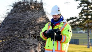
LiDAR, or Light Detection and Ranging, is a remote sensing technology that utilizes pulsed laser light to measure distances and create precise 3-D maps or models of environments for a variety of applications.
The three-day MCSC course is designed to provide students with an understanding of LiDAR technology and how it can be integrated with drones and extended reality (xR) environments. The aim is to provide them with the knowledge needed to collect, process and apply high-resolution spatial data for use in construction, infrastructure and environmental projects. The course is open to anyone with an interest in LiDAR, xR and construction technology. Experience operating a drone is an asset but isn’t mandatory. The cost of the program is $200 per student and is paid for by the employer in most cases.
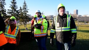
The first cohort of 20 students graduated from the program this past November and another 26 students were part of a second intake offered Jan. 21-23 at New Media Manitoba’s StudioLab xR training centre in Winnipeg. The program is an offshoot of the basic and advanced drone training courses the MCSC has been offering for several years.
MCSC executive director Carol Paul says development of the new course was “industry-driven” and was inspired by conversations with construction industry executives who noted that some companies were reluctant to adopt LiDAR and xR because they didn’t have anyone on staff experienced in using those technologies. That meant they often had to hire out-of-province contractors if they wanted to use that technology on a project.
“I think it’s so important this this is industry-driven because that’s when industry is going to listen,” Paul says. “If it’s someone like me telling them you need this, they’ll say what do you know about construction? But if you hear from a construction company that this is what’s need for the future of construction, now we’re getting buy-in. That’s sort of what prompted development of the program.”
New Media Manitoba provides the instruction for the xR portion of the program including how to interpret the data obtained using a drone. The MCSC hires industry experts to supply instruction on how to operate the LiDAR mapping drones.
Some of the topics covered during the course include: LiDAR fundamentals and real-world scanning missions; field-based LiDAR deployment using drones; LiDAR data processing workflows, formatting and integration: xR technologies including RealityCapture and Unreal Engine platforms; and advanced use cases in construction, infrastructure and training simulations.
Paul says one of the benefits to Manitoba construction companies adopting LiDAR and xR technology is that it will allow them to be more competitive with their counterparts in other parts of the country. Many new projects require companies to have experience using 3-D
technologies. Those that don’t are often shut out when it comes to the tendering process.
“I’ve talked to people that worked in Toronto and Vancouver and they were saying … we’re not keeping up with those major centres,” she says. “We can’t keep our head in the sand. We have to start looking at what are we going to do to be competitive with those other
provinces.”
In addition, LiDAR and xR can also support stronger decision-making, improve planning and reduce costly and time-consuming errors. It can also greatly enhance the safety of people working on construction sites. For example, it can be used to remotely assess the condition
of a bridge rather than sending an individual into a potentially dangerous situation to inspect it manually.
“The LiDAR drone can capture a 3-D image and you can see where the cracks are and assess what needs to be done … as opposed to having somebody hang off the bridge. How efficient is that,” Paul says.
Paul says the feedback from students who have taken the course has been extremely positive. “They love it,” she says.
Cobus Gerber, a pre-construction manager for Steinbach-based Three Way Builders, was one of the first graduates of the MCSC program. He was eager to take part in the course to augment his existing knowledge of computer systems and 3-D modelling.
“What I took from the course is mainly to open your mind to the possibility (of its use) in industry and where the industry is heading into, to have a good understanding of that and start to think about how can we implement this into our day-to-day operations to support the direction the industry is going into,” he says.
Gerber has already begun to use the knowledge that he gained in the course to create some 3-D models and he’s looking forward to seeing how the technology could be used on future projects.
“It’s a good idea for companies to educate themselves and set themselves up to keep up with the times. This is something I’d like to see us push ourselves towards and stay that one step ahead of the rest,” he explains.
MSCS’s LiDAR and xR course is part of a three-year initiative and receives $219,000 in annual funding through Manitoba Workforce Development.